Investigating Bedrock Morphology and Potential Applications for Predicting Landslides
Landslides are a serious geologic hazard common to almost every state and region across North America. Although gravity acting on an over-steepened slope is the primary reason for a landslide, there are many contributing factors including erosion from rivers, weakened rock and soil, or major events such as earthquakes. While the physical cause of many landslides cannot be removed, geologic investigations, good engineering practices, and effective enforcement of land-use management regulations can reduce landslide hazards.
Geomorphology is crucial to understanding the origin and evolution of landforms and how landscapes operate and will change over time to enable better environmental management.
Geotechnical studies play a key role in the evaluation of shoreline stabilization, habitat restoration, and contaminated sediment remedies. These geotechnical environmental site assessments have a vast impact, affecting multiple entities from the hydropower industry to rail owners and operators across the nation.
Can We Predict Future Landslides? River Morphology Provides Insight
Bedrock rivers play a major role in determining the pace of landscape evolution—cutting canyons, creating relief, and driving many of the landscape responses to changes in climate and tectonics. Bedrock is the hard, solid rock beneath surface materials, such as soil and gravel within the crust of the earth. In bedrock rivers, the bed and banks are made of bedrock, or have little alluvium covering bedrock that is close-to the-surface; They are the interface between surface hydrology and geology. Bedrock movements include some of the most common rockfalls, landslides, and avalanches.
Understanding the multiple attributes and contributing processes in these environments is required to conduct a comprehensive analysis of the hazards associated with bedrock mass movements. This may allow us to better mitigate future landslide risks that threaten communities and habitats. Some examples of relevant contributing attributes are properties of the material being eroded and characteristics of the erosive forces. The morphologies of individual bedrock-bound rivers, and how long they reach, are at least partially controlled by flow, sediment dynamics, and the geometry of the river walls.
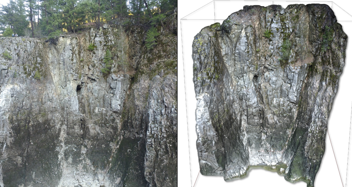
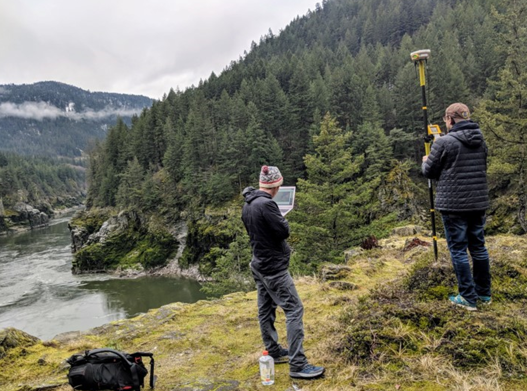
This photogrammetric model (right) allows engineers to better understand geological aspects of outcrops that are difficult to access (note humans in the upper left of the photo on left for scale). In this instance, photogrammetric models allowed engineers to better evaluate how the influence of the flow dynamics and rock structure in a bedrock canyon will compete with each other.
Understanding Why Constriction-Pool-Widening Morphologies Matter at Fraser River
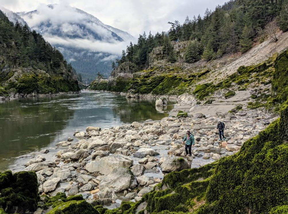
In 2019, the Fraser River—the longest river in British Columbia, Canada—suffered from a catastrophic failure within its high rocky cliffs, causing a major landslide into its remote canyon. Known as the Big Bar landslide, the rocks acted as a barrier to the migration of the already endangered salmon populations in the river.
To understand bedrock erosion at the large scale, we must understand the river morphology at the scale of an individual reach. At the reach scale, many bedrock rivers exhibit a constriction-pool-widening (CPW) morphology, where the river’s lateral constriction is followed by downstream channel widening. The processes acting to widen the channel downstream of the constriction-pool include undercutting of the walls at the channel margins. This can cause major landslides. Therefore, by looking at how CPW morphology emerges, we can better predict the locations of future landslides.
The CPW morphology is well expressed throughout the entire Fraser River system. Members of the River Dynamics Lab at Simon Fraser University and I investigated the role rock structures play in width variations in one canyon where the CPW morphology is present. What we found was that channels tend to narrow in areas of more competent bedrock and that highly fractured rock can enhance lateral erosion by lowering rock mass strength.
The Fraser River hosts a unique variety of fish, from white sturgeon and steelhead trout to every species of Pacific salmon.
This causes lateral constrictions (rock walls protruding into the river channel) and plunging flows that eventually promote pools by driving sediment into the bedrock below. Over time, the process enhances lateral erosion when the plunging water flows into both the bed and the outer walls. In this way, the geometry of the walls and the topography of the bed will evolve together. This illustrates an established link between constrictions, flow patterns down a river, and pools in bedrock canyons. We also examined pool widenings, which are most apparent at high flows. Geologic structure with vertical fractures in addition to width constrictions makes canyon walls more susceptible to failure by toppling the undercutting of the rock walls occurs due to plunging flows.
This vertical fracture, or jointing, geometry may help determine where a collapse is susceptible to occurring. Vertical jointing makes a canyon wall more likely to failure when undercut because it exposes new failure surfaces when supporting rock is removed from below. In contrast, for a horizontally jointed rock mass to fail when undercut, the weight of the rock above would have to overcome the tensile strength of a cohesive block of rock. Over time, this disparity in rock mass strength will lead to greater widths in areas where canyon walls are vertically jointed and relative constrictions in areas where canyon walls are horizontally jointed.
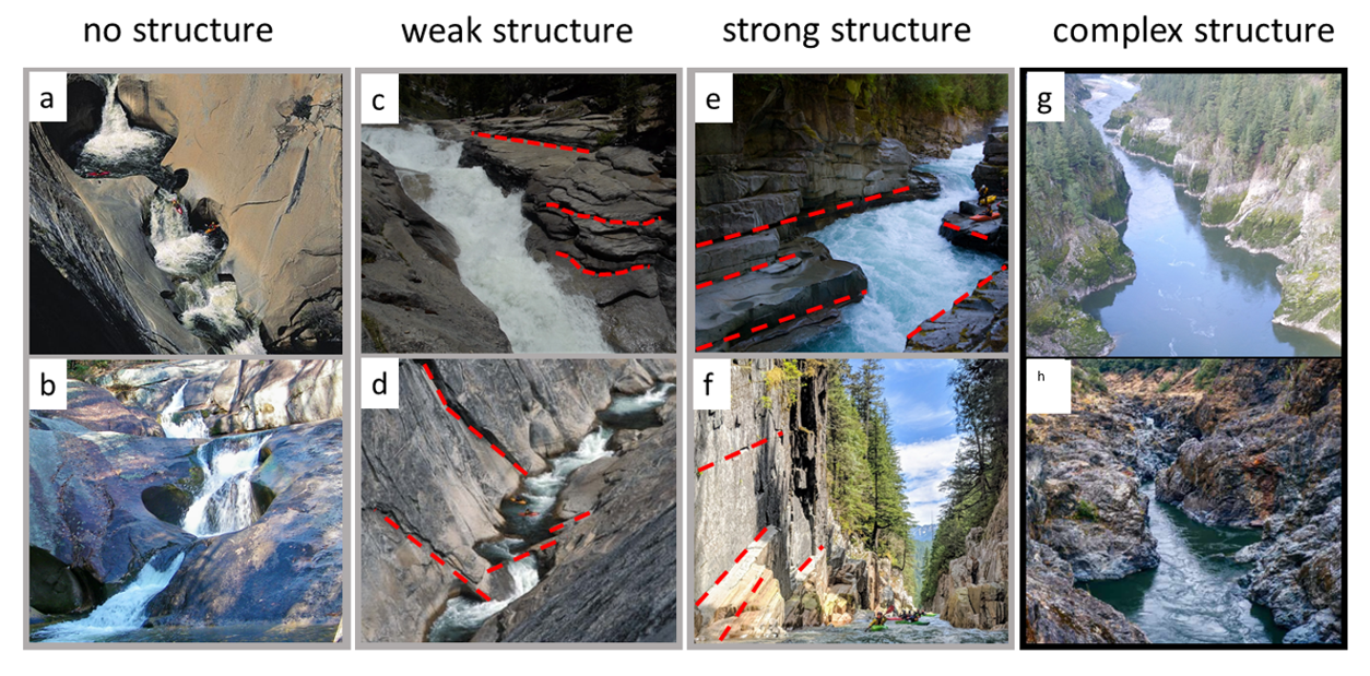
Bedrock canyon morphologies show a spectrum of structural controls and complex structures that coevolve with river flow.
Finding Patterns in Constriction-Pool-Widening Morphology to Assess Risk
CPW morphologies can form in homogenous rock, and an initial structural constriction can cause a series of propagating pools. This is because wall failures open the space for a backwater downstream of a scour pool, and therefore create a subsequent constriction and scour pool. With this mechanism, a canyon could evolve through the formation of multiple CPW morphological units that eventually either see collapse or become so deep that the plunging flows dissipate before they hit the bed. As structural influence gets stronger in a canyon, it will determine the morphology of the canyon more and more.
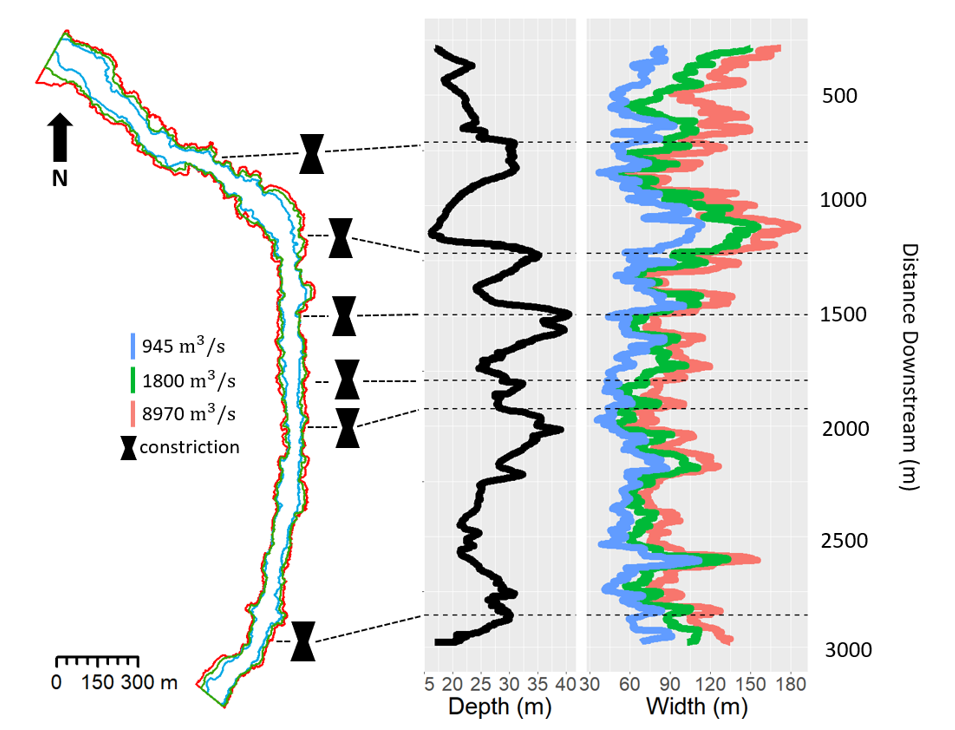
These variations in width and depth present in a pattern of CPW morphologies where constrictions cause plunging flows that undercut walls.
A pattern of CPWs can be either reinforced or dampened by the influence of relative differences in rock mass strength as determined by joint geometry. In other words, bedrock structure can impose control on a process that is otherwise self-occurring. These results have implications for the larger problem of understanding bedrock channel width at the scale of the entire river.
We proposed a conceptual model where vertical jointing leaves a rock wall more susceptible to failure when undercut and horizontal jointing promotes relative constrictions over time. Bedrock river erosion exhibits a morphologic sequence of constrictions and wide pools, a consequence of rock mass strength or geological structure along the channel. Widening is caused by vertical joining, which causes canyons to be more susceptible to toppling due to river undercutting.
Ultimately, in any canyon, the influence of the flow dynamics and the structure will always compete. However, this understanding of the evolution of landforms that experience landslides enables better environmental management. CPW morphology of bedrock rivers helps us effectively predict the locations of future landslides that are most likely to occur, which has been well expressed in the Fraser River. Bedrock rivers give us all an insight into the pace of landscape evolution and the environment’s responses to a changing climate. To mitigate future landslide risks that threaten communities, habitats, and critical infrastructure, it is imperative that we understand bedrock river morphology, along with the number of processes and environmental conditions dealing with river form changes due to sedimentation and erosion.